Overlooks Between Blowing Rock and Spruce Pine

Updated: April 2019
Stunning Views
Between Blowing Rock and Spruce Pine, the Blue Ridge Parkway offers many stops from where you can enjoy breathtaking long-range views of beautiful valleys and towering mountain ranges. The selection of our ten most favorite overlooks starts just north of Blowing Rock and ends near Spruce Pine. The order follows the Mileposts along the Blue Ridge Parkway.
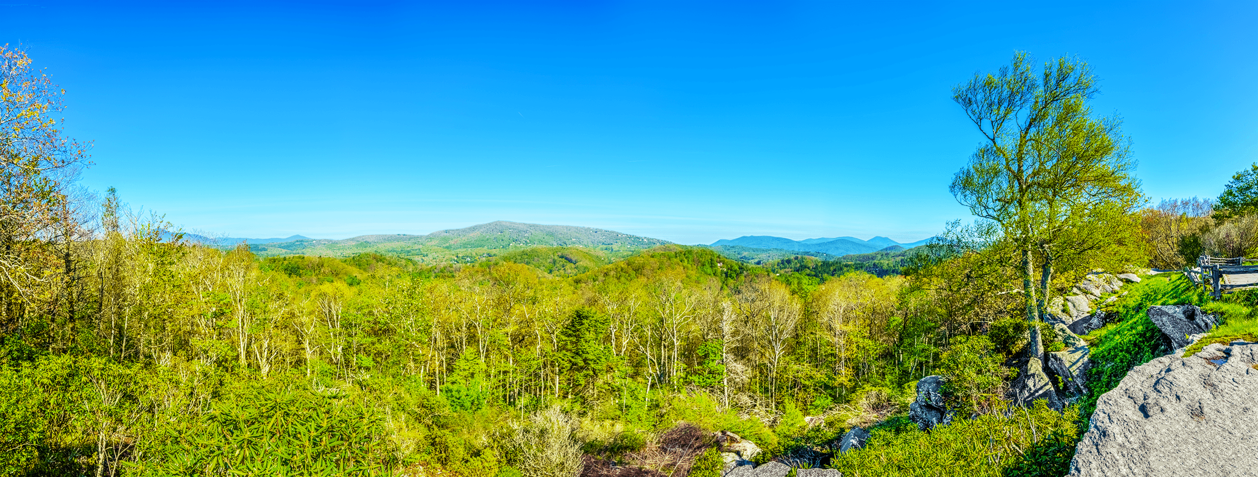
Raven Rocks Overlook faces Flat Top Mountain with an elevation of 4,469 feet (1,362 meters). To the west of Flat Top Mountain slightly behind the trees is Calloway Peak, the highest point of Grandfather Mountain with an elevation 5,964 feet (1,817 meters). To the east of Flat Top Mountain are Snakeden Mountain (4,485 feet - 1,367 meters), Rich Mountain (4,746 feet - 1,447 meters), Snake Mountain (5,568 feet - 1,697 meters) and Elk Knob (5,520 feet - 1,682 meters).
Raven Rocks Overlook, Milepost 289.5
The Raven Rocks Overlook at Milepost 289.5 on the Blue Ridge Parkway is one of only a few west facing overlooks along this stretch of the parkway, making it an ideal location, if you want to take pictures in the morning.
From an elevation of 3,810 feet (1,161 meters), the overlook faces Flat Top Mountain (4,469 feet - 1,362 meters).
On a sunny day, to the west of Flat Top Mountain in the far distance, you can see Calloway Peak, the highest point of Grandfather Mountain with an elevation 5,964 feet (1,817 meters).
To the far east of Flat Top Mountain is Elk Knob with an elevation of 5,520 feet (1,682 meters).

The east-facing Yadkin Valley Overlook is a small pull-off at Milepost 289.8 on the Blue Ridge Parkway. From an elevation of 3,830 feet (1,167 meters), the overlook offers sweeping panoramic views of the Yadkin Valley.
Yadkin Valley Overlook, Milepost 289.8
The Yadkin Valley Overlook is a small pull-off at Milepost 289.8 on the Blue Ridge Parkway, offering sweeping panoramic views of the Yadkin Valley.
From an elevation of 3,830 feet (1,167 meters), the overlook faces east.

The Thunder Hill Overlook is a popular photo stop. From an elevation of 3,795 feet (1,157 meters), you can take stunning panoramas of the Piedmont below. For best pictures, you may want to visit the overlook in the late afternoon or in the evening, when the sun is behind you, or in the early morning, when the sun shines from the east.
Thunder Hill Overlook, Milepost 290.7
The Thunder Hill Overlook is located at Milepost 290.4 along the Parkway. From an elevation of 3,795 feet (1,157 meters), you can enjoy expansive long-range views of the Piedmont below. The overlook with its stunning east facing views is a popular photo stop among tourists.
For the best pictures, you may want to visit the overlook in the late afternoon or the evening, when the sun is behind you.
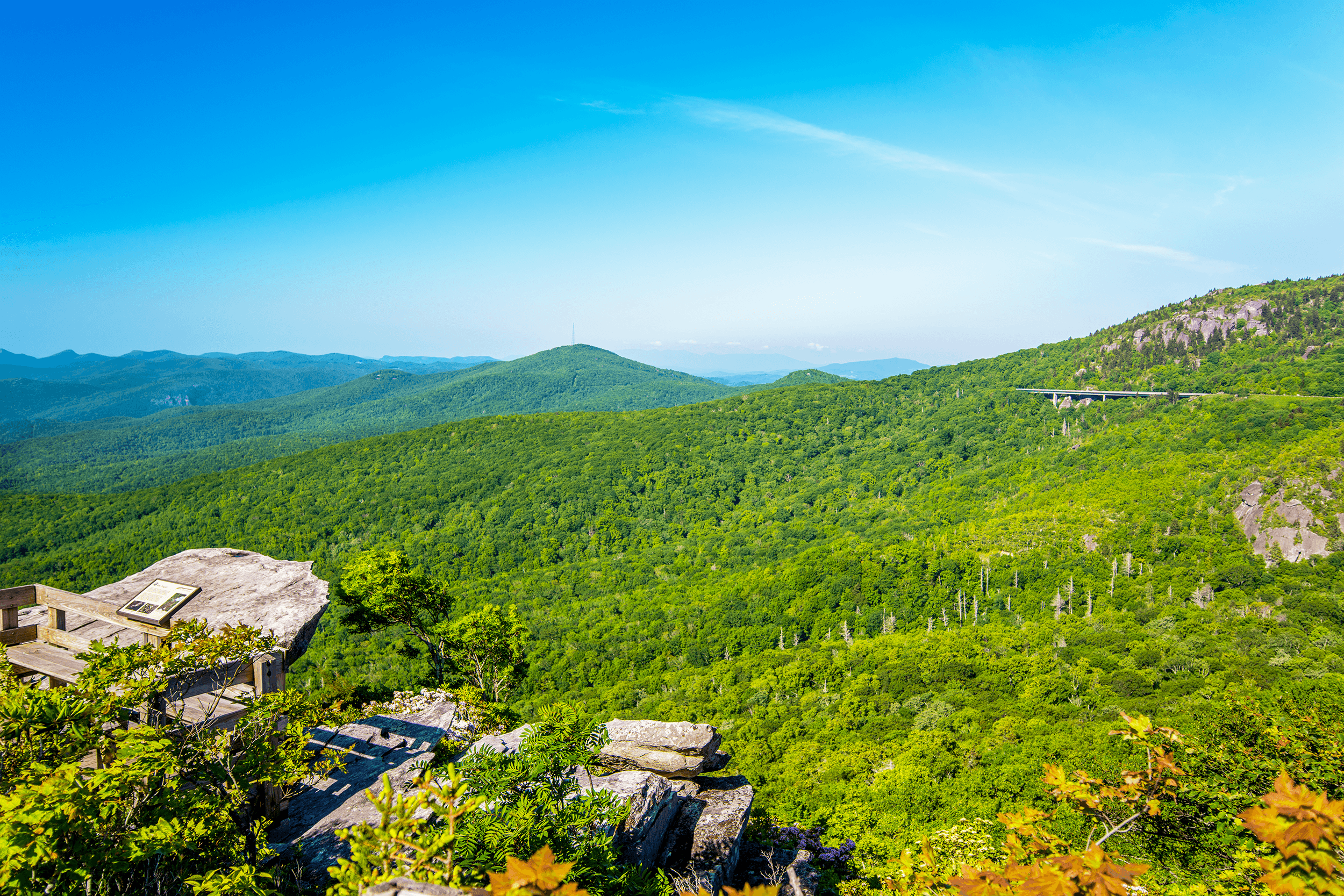
The Rough Ridge Overlook is located just 2 miles (3 km) from the Linn Cove Viaduct and offers not just picture-perfect views of this construction marvel, but also breathtaking panoramic views of Grandfather Mountain towering high above the Linn Cove Viaduct.

In case you visit the Rough Ridge Overlook in May or June, you will be able to admire the Catawba Rhododendron, named for the Catawba Indians, who lived east of the Catawba River. Blooming between late May and mid-June, the Catawba Rhododendron is also called “nature’s thermometer.” When the temperature drops, its leaves curl inward. It is said, at below 20°F (-7°C), the leaves are curled “as tight like a cigar.”
Rough Ridge Overlook, Milepost 302.8
This overlook requires some short but serious hiking until you reach the boardwalk and the viewing platform. If you are up to it and have firm running shoes or hiking boots (recommended), this overlook is well worth the extra effort.
The parking lot at Milepost 302.8 provides access to the Tanawha Trail, which stretches 13.5 miles (21.7 km) from Julian Price Memorial Park to → Beacon Heights.
When the access trail from the parking lot reaches the Tanawha Trail, turn left and follow the Tanawha Trail south.
After a steep ascent, the trail reaches a long wooden boardwalk and viewing platform, the Rough Ridge Overlook. The panoramic mountain views are just breathtaking. You can even see the famous Linn Cove Viaduct in the distance.
When you happen to visit the overlook in May or June, you will be able to admire the Catawba Rhododendron, named for the Catawba Indians, who lived east of the Catawba River. Blooming between late May and mid-June, the Catawba Rhododendron is also called “nature’s thermometer.” When the temperature drops, its leaves curl inward. It is said, at below 20°F (-7°C), the leaves are curled “as tight like a cigar.”

Send a lovely Greeting Card with a real photograph of the Rough Ridge Overlook
All Greeting Cards are handmade by us in the U.S.A.

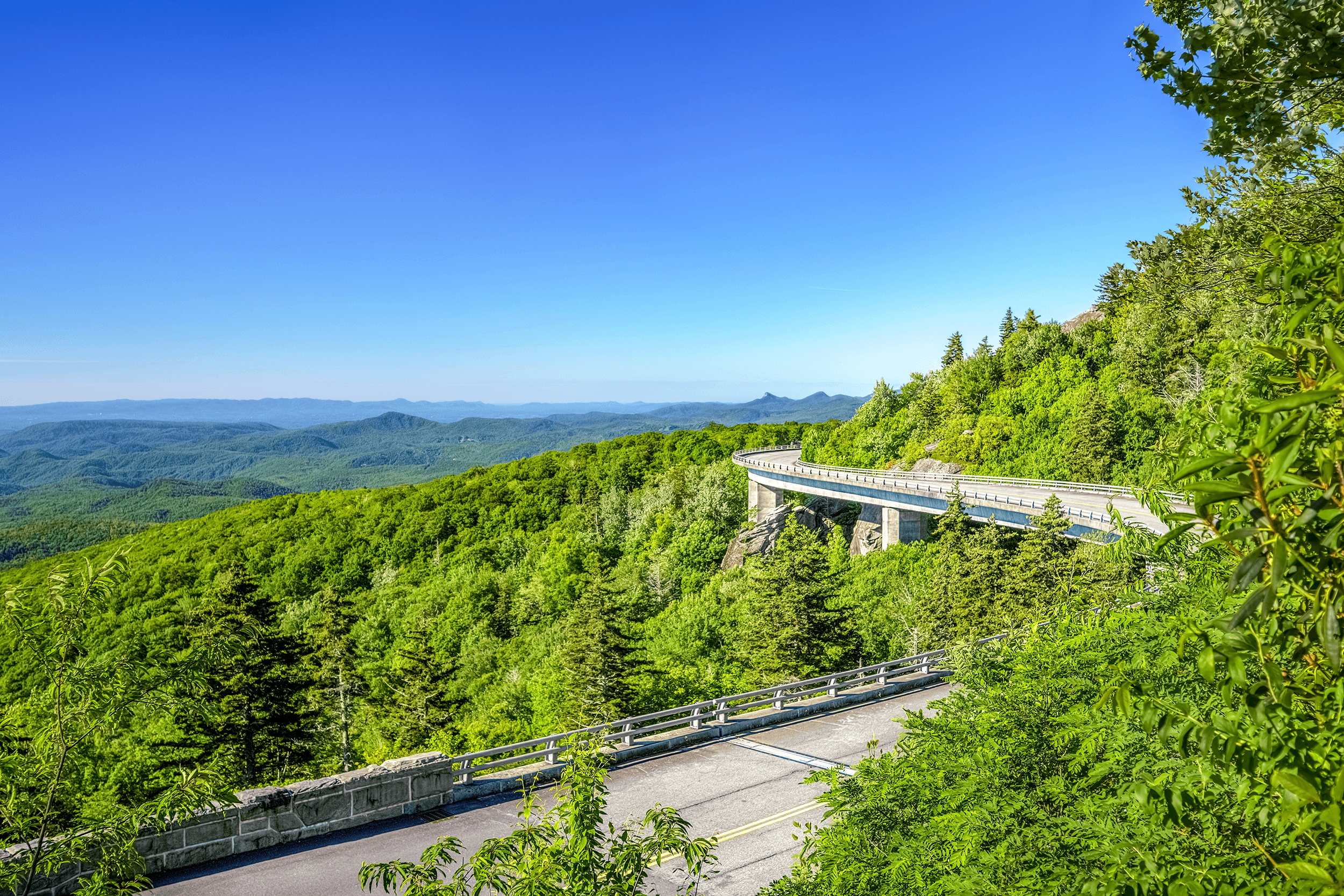
The Linn Cove Viaduct rests on seven giant concrete footings and follows in snake-shape form the contours of Grandfather Mountain without touching the slopes of Grandfather Mountain, making the viaduct an engineering marvel and one of the most photographed attractions along the Blue Ridge Parkway.
Yonahlossee Overlook, Milepost 303.9
Located just 0.2 miles (0.3 km) north of the Linn Cove Viaduct, the Yonahlossee Overlook (elevation 4,412 feet - 1,345 meters) allows you to study the famous viaduct from a close-up eye-level view. An easy 0.2-mile (0.3 km) trail along the Blue Ridge Parkway (separated by a guardrail) leads to the overlook.
The viaduct rests on seven giant concrete footings and follows in snake-shape form the contours of Grandfather Mountain. As it does not touch the slopes of Grandfather Mountain, the viaduct is considered an engineering marvel and one of the most photographed attractions along the Blue Ridge Parkway.
For best pictures, you may want to choose the mornings, when the rising sun is behind you and nicely brightens the viaduct.
If you want to learn more about the construction of the Linn Cove Viaduct, you may want to stop at the visitor center on the south side of the viaduct at Milepost 304.4.
After a short easy to moderate hike, the Beacon Heights Trail opens up to the south-facing rock formation. The surface of the rock is smooth and offers a perfect place for a nice picnic with incredible long-range views as a backdrop.
The north-east facing rock-dome offers spectacular views of Grandfather Mountain, towering high above the Beacon Heights Overlook. If you love long-range views and a fantastic place for a picnic, the Beacon Heights Overlook should be on your list.
Beacon Heights Overlook, Milepost 305.2
The Beacon Heights Overlook is probably one of the most scenic overlooks along the Blue Ridge Parkway. Located at Milepost 305.2, the overlook is just a short 0.4-mile (0.6 km) hike up from the parking lot. First, you cross a small road to get to the start of the 0.4-mile one-way Beacon Heights Trail.
The trail, which is typically only lightly trafficked, soon reaches a folk, branching off to the left into the Tanawha Trail. To the right, it continues as Beacon Heights Trail. After a short ascent, the Beacon Heights Trail continues left, leading to the Beacon Heights Overlook.
Close to the summit of Beacon Heights, the trail splits again.
The trail to the right leads to the south-facing rock formation with its smooth surface, which offers at an elevation of around 4,340 feet (1,323 meters) incredible long-range views and an excellent place for a picnic.
The trail to the left climbs to the north-east-facing rock dome with beautiful tree-framed views of Grandfather Mountain.

The west-facing North Toe River Valley Overlook at Milepost 318.4 is a favorite spot for mountain sunset views. Less known, however, is that this section of the Blue Ridge Parkway is the only section that follows closely an earlier scenic highway, the Crest of the Blue Ridge Highway, which was built in 1912, but whose construction was abandoned by 1917 when the U.S. entered WWI.
North Toe River Valley Overlook, Milepost 318.4
The west-facing North Toe River Valley Overlook at Milepost 318.4 offers beautiful sunset views from an elevation of 3,540 feet (1,079 meters).
The Toe River was initially known as Estatoe, a Cherokee Indian name for the beautiful little green Carolina parakeet, a small parrot with mostly green plumage and a long tail, which inhabited the Carolinas during early colonial times.
The name Estatoe or Eastatoe was widely used for creeks, rivers, valleys, gaps, and entire townships. Early settlers also called the local Cherokee people Eastatoes for their trade town of Eastatoe in what is today South Carolina.
Did You Know?
This section of the Blue Ridge Parkway between Mileposts 317.6 and 318 is the only section that follows an earlier scenic highway, the Crest of the Blue Ridge Highway.
In 1906, Joseph Hyde Pratt (1870-1942), who was North Carolina’s state geologist and member of the Commission of the Appalachian Forestry Reserve, proposed a toll road along the crest of the Blue Ridge Mountains from Whitetop Mountain near Marion VA to Tallulah Falls GA. This road became known as the Crest of the Blue Ridge Highway.
Foreseeing an increasing number of motorists looking for destinations to visit, he intended his scenic highway to attract vacationers to the region as much as the railway did before the automobile had emerged.
In 1912, the Appalachian Highway Company started to build the first 8 miles (13 km) of the unpaved roadway.
When the United States entered WWI in 1917, the project was abandoned.
In the 1930s, federal plans for the Blue Ridge Parkway incorporated much of Joseph Pratt’s concept including some of his proposed route.

The Chestoa View Overlook has two viewing platforms, which you reach after a short hike. A rock-walled platform, which is located circa 0.2 miles (0.3 km) from the parking area, offers spectacular long-range views overlooking Linville Gorge.

Here are the stunning views from the first platform. If you want to get to the second observation platform with views of Table Rock Mountain, follow the 0.6-mile (1 km) Chestoa View Trail.
Chestoa View Overlook, Milepost 320.8
The Chestoa View Overlook at Milepost 320.8 offers from its two scenic viewing platforms spectacular long-range views of the Linville Gorge as well as a stunning panoramic view of Table Rock Mountain.
From the parking area, follow a short 0.2-mile (0.3 km) paved trail to the Chestoa View Trail sign. To get to the first viewing platform, which overlooks Linville Gorge, turn left at the sign and follow a stone staircase downhill to a rock-walled observation platform. From here at an elevation of 4,081 feet (1,244 meters), visitors can enjoy unobstructed long-range views overlooking Linville Gorge.
If you want to explore the other platform, follow the easy to moderate 0.6-mile (1 km) Chestoa View Trail, which is essentially a loop. After a couple of minutes hike, passed the sign, the trail splits forming a circle.
The quickest way to reach the second overlook is to follow the trail on the left. There is a bench nearby, from which you can savor the scenery and the moment.

Bear Den Overlook: On the left of the panorama is Dobson Knob (3,694 feet - 1,126 meters). The historic Overmountain Victory Trail runs to the east of Dobson Knob. The Overmountain Men took this trail during the American Revolutionary War (1775-1783) to face the advancing British troops. In the Battle of Kings Mountain on October 7, 1780, the British suffered a surprising defeat, which probably played a large part in the outcome of the war.
Bear Den Overlook, Milepost 323
Named for bear dens, which were once in the area, the Bear Den Overlook is located at Milepost 323.
From an elevation of 3,359 feet (1,024 meters), you can enjoy scenic south facing 180° views, which include Dobson Knob (3,694 feet - 1,126 meters) and Jackson Knob (3,409 feet - 1,039 meters).
The Overmountain Victory Trail
The historic Overmountain Victory Trail runs to the east of Dobson Knob.
During the American Revolutionary War (1775-1783), the trail was taken by the Overmountain Men, a militia of volunteers from Virginia, North Carolina, Tennessee, and Kentucky, who were on their way to the decisive Battle of Kings Mountain on October 7, 1780 (The Historic McDowell House).
At this battle the British suffered a surprising war altering defeat, leading to the withdrawal of British forces from Charlotte on October 12, 1780, and retreat to South Carolina.

From an elevation of 2,815 feet (858 meters), the North Cove Overlook offers long-range views down Pepper Creek Valley. The view is towards North Cove NC, which lies 3 miles (5 km) away, and for which the overlook was named. The North Cove Overlook is situated above a challenging 13-mile (21-km) railroad section that connects Spruce Pine NC with Marion NC through multiple loops and 18 railroad tunnels.

The Historic Orchard at Altapass is a popular stop for visitors wanting to pick their apples during the harvest season from September to October or to hike the beautiful orchard on a sunny day.
North Cove Overlook, Milepost 327.3
Located at Milepost 327.3 and an elevation of 2,815 feet (858 meters), North Cove Overlook offers long-range views down Pepper Creek Valley towards North Cove NC, which lies 3 miles (5 km) away, and for which the overlook was named.
The red colored building, which can be seen 1 mile (1.6 km) away on the right, is The Historic Orchard at Altapass, an over 100-year old apple orchard. The orchard is not just a popular stop for visitors, wanting to pick their apples during the harvest season from September to October, the farm, during the same time, is also a favorite stop for thousands of migrating monarch butterflies.
Sometimes you can hear the whistle from freight trains winding through this challenging terrain below. With its 18 tunnels and multiple loops, this 13-mile (21-km) stretch was an engineering marvel back in 1908, when the Clinchfield Railroad completed it.
You can still see sections of the railroad tracks from the overlook.
The Clinchfield Railroad
Initially, the South & Western Railroad Company ran a line from Johnston City TN to Spruce Pine NC, where it ended.
Attempting to connect the coal fields in Kentucky with the lower southeastern states through Spartanburg SC, the railroad decided to extend the line south from Spruce Pine NC through the McKinney Gap.
From 1905 to 1908, approximately 4,000 workmen, mainly immigrants from Russia, Germany, and Italy, blasted and hammered their way through the mountains, laying 13 miles (21 km) of railroad tracks and building 18 tunnels. This section was later called The Loops, and the McKinney Gap renamed to Altapass, meaning high pass, marking the highest point of the railroad line between the coal region around Elkhorn City KY and Spartanburg SC.
When the line opened in 1908, the railroad was renamed to Carolina, Clinchfield & Ohio Railway.
Besides Marion NC, Altapass became an important stop and featured a resort hotel and golf course, bringing tourists to the area.
Although passenger service was discontinued in the 1910s, the line was heavily used to transport coal, lumber, and minerals to markets in the southern states.
This railroad line is still in use today.
From Milepost 289.5 (Raven Rocks Overlook) to Milepost 327.3 (North Cove Overlook) on the Blue Ridge Parkway
All day.
All year.
Certain sections of the Blue Ridge Parkway may be closed during winter.
All overlooks have free parking.
The Raven Rocks Overlook, the Yadkin Valley Overlook, the Thunder Hill Overlook, the North Toe River Valley Overlook, the Bear Den Overlook and the North Cover Overlook can be enjoyed from the car or from the parking lot.
Hiking trails range from the easy to strenuous.
Hiking boots are recommended.
Please use your own discretion.
If you have a little time and do not mind a short easy to moderate hike, our favorite for a picnic is the Beacon Heights Overlook at Milepost 305.2. There are no picnic tables, but the surface of the rock is smooth and the view is just breathtaking.